Newest reports appear first. Select a report for details.
Community updates
Everyone can report local conditions
Not enough verified reports in the past 6 hours
How is the situation summarised?
At least 4 verified reporters at the same location within 6 hours are required. Only each person's latest report counts. Conflicting rising and falling reports are flagged for review.
“Not falling” does not mean “rising”. Reports older than 6 hours are excluded. Community summaries do not change official alert colours. Falling water does not confirm that roads are open or safe.
Road information from multiple sources
Last synced Mon 5 Oct 2026 12:00
Subdistrict: Khu Yai Mi District: Sanam Chai Khet · News report
At 08:30, all vehicles could pass using the right lane, where water was below half-wheel height. Water was deeper in parts of the left lane, especially near the traffic light. High-clearance vehicles, ten-wheel trucks, and trailers could use the left lane, but their wake could hit roadside homes, so that lane was not recommended. Water was higher beyond the traffic light, and a vehicle had stalled on the Plaeng Yao-bound side. Reduce speed and check the latest status before travelling.
On the morning of 4 Oct 2026, standing floodwater was reported to be rising continuously and travel was difficult. Avoid the route, especially in small vehicles and on motorcycles. If travel is essential, use extra caution and follow the latest updates. The report gave only a morning time and no measured depth.
Subdistrict: Bang Tin Pet District: Mueang Chachoengsao
Village entrance, Ben 2, Wat Don Thong School, Wat Don Thong, Soi Wat St Paul, and Sirarom Don Thong village
Use caution · ข้อมูลล่าสุดที่มี · รอยืนยันปัจจุบัน
At 07:30, water was reported beginning to overflow from the roadside near the village entrance, Ben 2, Wat Don Thong School, Wat Don Thong, Soi Wat St Paul, and Sirarom Don Thong village. Travel carefully and monitor water levels.
Use caution · ข้อมูลล่าสุดที่มี · รอยืนยันปัจจุบัน
At 22:20, water was reported entering the area. Vehicles could still pass, but water was rising and approximately 10–20 cm deep. This was a point report at the stated time.
At 16:29, the bridge was reported closed for about four hours and expected to reopen around 20:30. Officials were installing water-pushing equipment to speed drainage. Avoid the route and plan ahead. This report describes conditions at the stated time; check the latest status before travelling.
At 10:27, flooding covered both frontage lanes and extended into one main lane. Only one lane was passable, with queued and slow-moving traffic. Traffic improved beyond the flooded section. Reduce speed, allow extra time, and check the latest status before travelling.
Awaiting source verification · Approximately Sat 3 Oct 2026 11:00 Road conditions may have changed. Check before travelling.
District: Mueang Chachoengsao
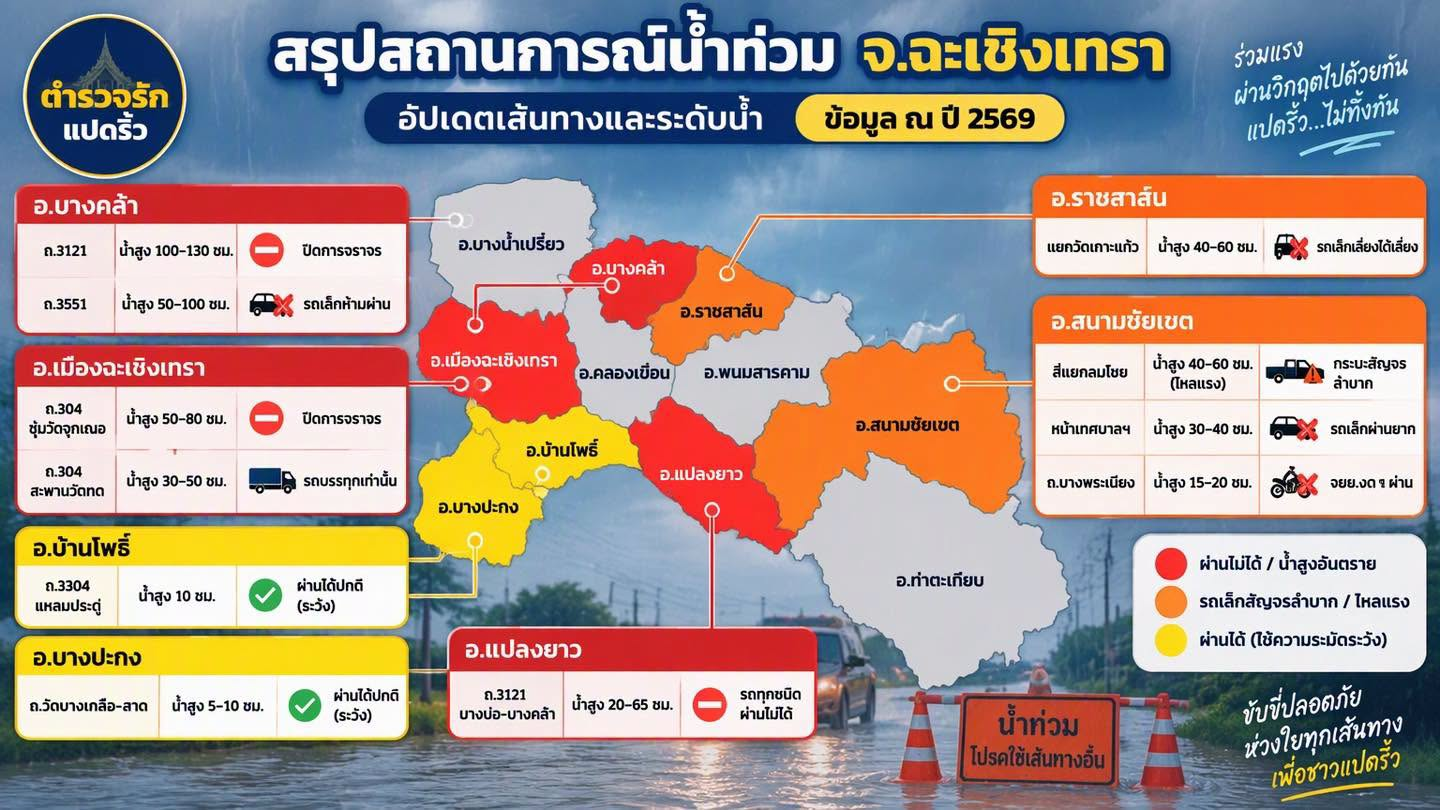
Road 304 · Wat Chuk Krachoe arch
สถานะล่าสุดที่มี: Road closed · รอยืนยันปัจจุบัน
Previously reported
Road closed
Reported water depth 50–80 cm
Approximately Sat 3 Oct 2026 11:00 · As stated by the sender
Details and source
Transcribed from user-supplied images and text. No original post link or latest closure/reopening announcement is available yet.
Subdistrict, coordinates, kilometre markers and traffic direction are unconfirmed. Do not use this to choose a detour or determine whether vehicles can pass.
Approximately Sat 3 Oct 2026 11:00 · As stated by the sender
Details and source
Transcribed from user-supplied images and text. No original post link or latest closure/reopening announcement is available yet.
Subdistrict, coordinates, kilometre markers and traffic direction are unconfirmed. Do not use this to choose a detour or determine whether vehicles can pass.
Approximately Sat 3 Oct 2026 11:00 · As stated by the sender
Details and source
Transcribed from user-supplied images and text. No original post link or latest closure/reopening announcement is available yet.
Subdistrict, coordinates, kilometre markers and traffic direction are unconfirmed. Do not use this to choose a detour or determine whether vehicles can pass.
สถานะล่าสุดที่มี: No small vehicles · รอยืนยันปัจจุบัน
Previously reported
No small vehicles
Reported water depth 50–100 cm
Approximately Sat 3 Oct 2026 11:00 · As stated by the sender
Details and source
Transcribed from user-supplied images and text. No original post link or latest closure/reopening announcement is available yet.
Subdistrict, coordinates, kilometre markers and traffic direction are unconfirmed. Do not use this to choose a detour or determine whether vehicles can pass.
สถานะล่าสุดที่มี: Closed to all vehicles · รอยืนยันปัจจุบัน
Previously reported
Closed to all vehicles
Reported water depth 20–65 cm
Approximately Sat 3 Oct 2026 11:00 · As stated by the sender
Details and source
Transcribed from user-supplied images and text. No original post link or latest closure/reopening announcement is available yet.
Subdistrict, coordinates, kilometre markers and traffic direction are unconfirmed. Do not use this to choose a detour or determine whether vehicles can pass.
สถานะล่าสุดที่มี: Small vehicles should avoid this route · รอยืนยันปัจจุบัน
Previously reported
Small vehicles should avoid this route
Reported water depth 40–60 cm
Approximately Sat 3 Oct 2026 11:00 · As stated by the sender
Details and source
Transcribed from user-supplied images and text. No original post link or latest closure/reopening announcement is available yet.
Subdistrict, coordinates, kilometre markers and traffic direction are unconfirmed. Do not use this to choose a detour or determine whether vehicles can pass.
สถานะล่าสุดที่มี: Difficult for pickup trucks (strong current) · รอยืนยันปัจจุบัน
Previously reported
Difficult for pickup trucks (strong current)
Reported water depth 40–60 cm
Approximately Sat 3 Oct 2026 11:00 · As stated by the sender
Details and source
Transcribed from user-supplied images and text. No original post link or latest closure/reopening announcement is available yet.
Subdistrict, coordinates, kilometre markers and traffic direction are unconfirmed. Do not use this to choose a detour or determine whether vehicles can pass.
In front of a municipal office (office not specified)
สถานะล่าสุดที่มี: Difficult for small vehicles · รอยืนยันปัจจุบัน
Previously reported
Difficult for small vehicles
Reported water depth 30–40 cm
Approximately Sat 3 Oct 2026 11:00 · As stated by the sender
Details and source
Transcribed from user-supplied images and text. No original post link or latest closure/reopening announcement is available yet.
Subdistrict, coordinates, kilometre markers and traffic direction are unconfirmed. Do not use this to choose a detour or determine whether vehicles can pass.
สถานะล่าสุดที่มี: Motorcycles should not pass · รอยืนยันปัจจุบัน
Previously reported
Motorcycles should not pass
Reported water depth 15–20 cm
Approximately Sat 3 Oct 2026 11:00 · As stated by the sender
Details and source
Transcribed from user-supplied images and text. No original post link or latest closure/reopening announcement is available yet.
Subdistrict, coordinates, kilometre markers and traffic direction are unconfirmed. Do not use this to choose a detour or determine whether vehicles can pass.
สถานะล่าสุดที่มี: Passable with caution · รอยืนยันปัจจุบัน
Previously reported
Passable with caution
Reported water depth 10 cm
Approximately Sat 3 Oct 2026 11:00 · As stated by the sender
Details and source
Transcribed from user-supplied images and text. No original post link or latest closure/reopening announcement is available yet.
Subdistrict, coordinates, kilometre markers and traffic direction are unconfirmed. Do not use this to choose a detour or determine whether vehicles can pass.
สถานะล่าสุดที่มี: Passable with caution · รอยืนยันปัจจุบัน
Previously reported
Passable with caution
Reported water depth 5–10 cm
Approximately Sat 3 Oct 2026 11:00 · As stated by the sender
Details and source
Transcribed from user-supplied images and text. No original post link or latest closure/reopening announcement is available yet.
Subdistrict, coordinates, kilometre markers and traffic direction are unconfirmed. Do not use this to choose a detour or determine whether vehicles can pass.
Approximately 11:00 on 3 Oct 2026, based on information supplied by the user. The original image shows only the year 2026 and does not state a date or time.
Automatic updates combine multiple sources, but road conditions change quickly. Check the source and follow officers’ signs before passing.
Road reports for the selected area: 11 locations. Data from approximately Sat 3 Oct 2026 11:00. Current conditions are unconfirmed. Check before travelling.