Sanam Chai Khet · district-level report, exact location not provided
Water depth unknown · Water has fallen
Updated Sun 4 Oct 2026 21:358RIEW
The same summary used for speech playback, available without sound
All help channels, including text and sign language servicesChoose a brand, then choose a district
Reports may remain in their original language.
Back to noticesRoads and travel · Chachoengsao
Newest reports appear first. Select a report for details.
Latest updates from every category
Water depth unknown · Water has fallen
Updated Sun 4 Oct 2026 21:35Last synced Tue 6 Oct 2026 06:00
Subdistrict: Khu Yai Mi District: Sanam Chai Khet
Damaged road · Latest available information · Awaiting current confirmation
Road damage was reported. Open the source to check the exact location and latest time before travelling.
Latest observation Mon 5 Oct 2026 12:00
No recent road reports have been reviewed yet
Awaiting source verification · Approximately Sat 3 Oct 2026 11:00
Road conditions may have changed. Check before travelling.
District: Sanam Chai Khet
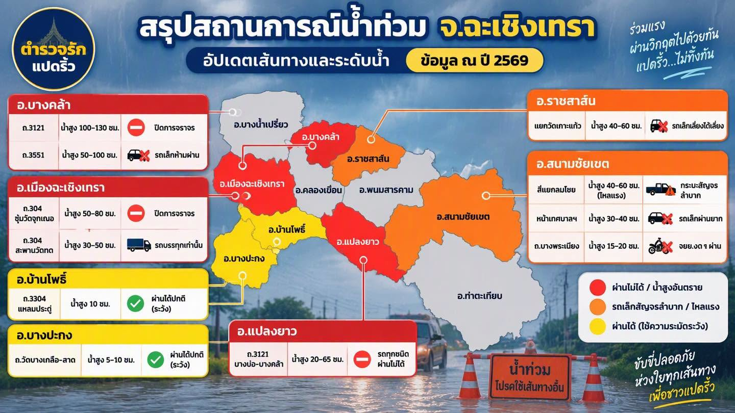
Latest available status: Difficult for pickup trucks (strong current) · Awaiting current confirmation
Difficult for pickup trucks (strong current)
Reported water depth 40–60 cm
Approximately Sat 3 Oct 2026 11:00 · As stated by the sender
This record does not yet include the latest closure or reopening notice.
Subdistrict, coordinates, kilometre markers and traffic direction are unconfirmed. Do not use this to choose a detour or determine whether vehicles can pass.
Reference images and timesDistrict: Sanam Chai Khet
Latest available status: Difficult for small vehicles · Awaiting current confirmation
Difficult for small vehicles
Reported water depth 30–40 cm
Approximately Sat 3 Oct 2026 11:00 · As stated by the sender
This record does not yet include the latest closure or reopening notice.
Subdistrict, coordinates, kilometre markers and traffic direction are unconfirmed. Do not use this to choose a detour or determine whether vehicles can pass.
Reference images and timesDistrict: Sanam Chai Khet
Latest available status: Motorcycles should not pass · Awaiting current confirmation
Motorcycles should not pass
Reported water depth 15–20 cm
Approximately Sat 3 Oct 2026 11:00 · As stated by the sender
This record does not yet include the latest closure or reopening notice.
Subdistrict, coordinates, kilometre markers and traffic direction are unconfirmed. Do not use this to choose a detour or determine whether vehicles can pass.
Reference images and timesApproximately 11:00 on 3 Oct 2026, based on information supplied by the user. The original image shows only the year 2026 and does not state a date or time.
Image colours are the creator's grouping. They do not represent current district-wide risk.