วัดไผ่แก้ว
Confirmed service available · FloodThai ระบุว่าเปิดเป็นศูนย์พักพิง โปรดโทรตรวจสอบสถานะและพื้นที่ว่างก่อนเดินทาง
Updated Thu 8 Oct 2026 00:008RIEW
The same summary used for speech playback, available without sound
All help channels, including text and sign language servicesChoose a brand, then choose a district
Roads and travel · Chachoengsao
Newest reports appear first. Select a report for details.
Latest updates from every category
Confirmed service available · FloodThai ระบุว่าเปิดเป็นศูนย์พักพิง โปรดโทรตรวจสอบสถานะและพื้นที่ว่างก่อนเดินทาง
Updated Thu 8 Oct 2026 00:00Confirmed service available · FloodThai ระบุว่าเปิดเป็นศูนย์พักพิง โปรดโทรตรวจสอบสถานะและพื้นที่ว่างก่อนเดินทาง
Updated Thu 8 Oct 2026 00:00Vehicle restrictions / difficult passage · ผ่านได้: รถบรรทุก
Updated Wed 7 Oct 2026 16:53Confirmed service available · Food, drinking water and other supplies may be donated here. Check the latest needs before travelling.
Updated Sun 4 Oct 2026 18:56Vehicle restrictions / difficult passage
Updated Sun 4 Oct 2026 08:30Last synced Thu 8 Oct 2026 00:01
No automatically collected reports are available yet. Review local reports below and verify conditions before travelling.
Subdistrict: Plaeng Yao District: Plaeng Yao
Vehicle restrictions / difficult passage · Latest available information · Awaiting current confirmation
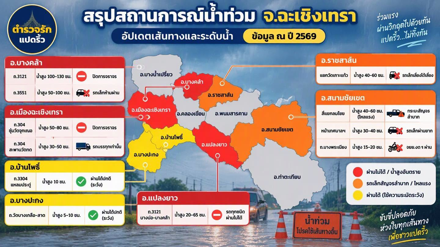
ข้อความที่ผู้ใช้ส่งให้ 8riew เวลา 16:53 น. ระบุวันที่ 7 ต.ค. 2569 ว่า ถนน 3121 บางคล้า–แปลงยาว ในเขตแปลงยาวน้ำเริ่มแห้ง เหลือน้ำบางจุดและรถผ่านได้ แต่จากปากซอยร้านทองพันชั่งมุ่งหน้าวงเวียนบางคล้ายังมีน้ำท่วมสูงและตามขอบถนน รถเล็กยังผ่านไม่ได้ รถขนาดตั้งแต่สิบล้อขึ้นไปผ่านได้สะดวก แนะนำใช้ถนน 3551 หัวสำโรง–หนองปลาตะเพียน ซึ่งใช้งานได้ตามปกติตามรายงานเดียวกัน ต้นฉบับระบุวันที่แต่ไม่ระบุเวลาเกิดเหตุ
Vehicles confirmed able to pass: Trucks
Latest observation Wed 7 Oct 2026 16:53
Subdistrict: Plaeng Yao District: Plaeng Yao
Vehicle restrictions / difficult passage · Latest available information · Awaiting current confirmation
At 08:30, all vehicles could pass using the right lane, where water was below half-wheel height. Water was deeper in parts of the left lane, especially near the traffic light. High-clearance vehicles, ten-wheel trucks, and trailers could use the left lane, but their wake could hit roadside homes, so that lane was not recommended. Water was higher beyond the traffic light, and a vehicle had stalled on the Plaeng Yao-bound side. Reduce speed and check the latest status before travelling.
Latest observation Sun 4 Oct 2026 08:30
Awaiting source verification · Approximately Sat 3 Oct 2026 11:00
Road conditions may have changed. Check before travelling.
Subdistricts cannot yet be identified for this dataset. District reports are not treated as subdistrict data. District road reports
Approximately 11:00 on 3 Oct 2026, based on information supplied by the user. The original image shows only the year 2026 and does not state a date or time.
Image colours are the creator's grouping. They do not represent current district-wide risk.