หอประชุม ทต.วังเย็น
Confirmed service available · FloodThai ระบุว่าเปิดเป็นศูนย์พักพิง โปรดโทรตรวจสอบสถานะและพื้นที่ว่างก่อนเดินทาง
Updated Tue 6 Oct 2026 18:008RIEW
The same summary used for speech playback, available without sound
All help channels, including text and sign language servicesChoose a brand, then choose a district
Reports may remain in their original language.
Back to noticesRoads and travel · Chachoengsao
Newest reports appear first. Select a report for details.
Latest updates from every category
Confirmed service available · FloodThai ระบุว่าเปิดเป็นศูนย์พักพิง โปรดโทรตรวจสอบสถานะและพื้นที่ว่างก่อนเดินทาง
Updated Tue 6 Oct 2026 18:00Confirmed service available · FloodThai ระบุว่าเปิดเป็นศูนย์พักพิง โปรดโทรตรวจสอบสถานะและพื้นที่ว่างก่อนเดินทาง
Updated Tue 6 Oct 2026 18:00Confirmed service available · FloodThai ระบุว่าเปิดเป็นศูนย์พักพิง โปรดโทรตรวจสอบสถานะและพื้นที่ว่างก่อนเดินทาง
Updated Tue 6 Oct 2026 18:00Confirmed service available · FloodThai ระบุว่าเปิดเป็นศูนย์พักพิง โปรดโทรตรวจสอบสถานะและพื้นที่ว่างก่อนเดินทาง · รองรับได้ 80 คน
Updated Tue 6 Oct 2026 18:00Confirmed service available · FloodThai ระบุว่าเปิดเป็นศูนย์พักพิง โปรดโทรตรวจสอบสถานะและพื้นที่ว่างก่อนเดินทาง
Updated Tue 6 Oct 2026 18:00Last synced Tue 6 Oct 2026 18:00
Across Chachoengsao province
Use caution · Latest available information · Awaiting current confirmation
A caution report was found. Open the source to check the exact location and latest time before travelling.
Latest observation Tue 6 Oct 2026 12:00
Across Chachoengsao province
Road closed / impassable · Latest available information · Awaiting current confirmation
A road closure or impassable route was reported. Open the source to check the exact location and latest time before travelling.
Latest observation Tue 6 Oct 2026 10:18
Subdistrict: Khu Yai Mi District: Sanam Chai Khet
Damaged road · Latest available information · Awaiting current confirmation
Road damage was reported. Open the source to check the exact location and latest time before travelling.
Latest observation Mon 5 Oct 2026 12:00
Across Chachoengsao province
Use caution · Latest available information · Awaiting current confirmation
A caution report was found. Open the source to check the exact location and latest time before travelling.
Latest observation Sun 4 Oct 2026 20:26
Subdistrict: Bang Khanak District: Bang Nam Priao
Road closed / impassable · Latest available information · Awaiting current confirmation
A road closure or impassable route was reported. Open the source to check the exact location and latest time before travelling.
Latest observation Sun 4 Oct 2026 19:25
Subdistrict: Bang Khanak District: Bang Nam Priao
Vehicle restrictions / difficult passage · Latest available information · Awaiting current confirmation
Vehicle restrictions or difficult passage were reported; the source lists small vehicles as passable. Open the source to check the exact location and latest time before travelling.
Vehicles reported as passable: Small cars
Latest observation Sun 4 Oct 2026 17:40
Across Chachoengsao province
Use caution · Latest available information · Awaiting current confirmation
A caution report was found. Open the source to check the exact location and latest time before travelling.
Latest observation Sun 4 Oct 2026 14:00
Across Chachoengsao province
Damaged road · Latest available information · Awaiting current confirmation
Road damage was reported. Open the source to check the exact location and latest time before travelling.
Latest observation Sun 4 Oct 2026 13:36
District: Phanom Sarakham
Damaged road · Latest available information · Awaiting current confirmation
Road damage was reported. Open the source to check the exact location and latest time before travelling.
Latest observation Sat 26 Sep 2026 12:00
Subdistrict: Plaeng Yao District: Plaeng Yao
Road closed / impassable · Latest available information · Awaiting current confirmation
มีป้ายปิดทาง ถนน 3121 ช่วงปากซอยเข้าร้านทองพันชั่ง–แยกบางคล้า ปิดการจราจร ผ่านไม่ได้ ระยะตามพิกัดประมาณ 2.7 กม. ผู้เดินทางจาก อ.แปลงยาว ไป อ.บางคล้า โปรดหลีกเลี่ยง เครดิต: TikTok หนุ่ยแสตมป์ 2 เขียว
Latest observation Tue 6 Oct 2026 09:00
Subdistrict: Nong Bua District: Ban Pho
Vehicle restrictions / difficult passage · Latest available information · Awaiting current confirmation
At 10:00, standing water and heavy, slow-moving traffic were reported. Allow extra time, reduce speed, and check the latest status before travelling.
Latest observation Sun 4 Oct 2026 10:00
Subdistrict: Plaeng Yao District: Plaeng Yao
Vehicle restrictions / difficult passage · Latest available information · Awaiting current confirmation
At 08:30, all vehicles could pass using the right lane, where water was below half-wheel height. Water was deeper in parts of the left lane, especially near the traffic light. High-clearance vehicles, ten-wheel trucks, and trailers could use the left lane, but their wake could hit roadside homes, so that lane was not recommended. Water was higher beyond the traffic light, and a vehicle had stalled on the Plaeng Yao-bound side. Reduce speed and check the latest status before travelling.
Latest observation Sun 4 Oct 2026 08:30
Subdistrict: Pak Nam District: Bang Khla
Vehicle restrictions / difficult passage · Latest available information · Awaiting current confirmation
On the morning of 4 Oct 2026, standing floodwater was reported to be rising continuously and travel was difficult. Avoid the route, especially in small vehicles and on motorcycles. If travel is essential, use extra caution and follow the latest updates. The report gave only a morning time and no measured depth.
Latest observation Sun 4 Oct 2026 08:00
Subdistrict: Bang Tin Pet District: Mueang Chachoengsao
Use caution · Latest available information · Awaiting current confirmation
At 07:30, water was reported beginning to overflow from the roadside near the village entrance, Ben 2, Wat Don Thong School, Wat Don Thong, Soi Wat St Paul, and Sirarom Don Thong village. Travel carefully and monitor water levels.
Latest observation Sun 4 Oct 2026 07:30
Subdistrict: Nong Bua District: Ban Pho
Use caution · Latest available information · Awaiting current confirmation
At 22:20, water was reported entering the area. Vehicles could still pass, but water was rising and approximately 10–20 cm deep. This was a point report at the stated time.
Latest observation Sat 3 Oct 2026 22:20
Subdistrict: Bang Kaeo District: Mueang Chachoengsao
Road closed / impassable · Latest available information · Awaiting current confirmation
At 16:29, the bridge was reported closed for about four hours and expected to reopen around 20:30. Officials were installing water-pushing equipment to speed drainage. Avoid the route and plan ahead. This report describes conditions at the stated time; check the latest status before travelling.
Latest observation Sat 3 Oct 2026 16:29
Subdistrict: Khlong Chuk Krachoe District: Mueang Chachoengsao
Vehicle restrictions / difficult passage · Latest available information · Awaiting current confirmation
At 10:27, flooding covered both frontage lanes and extended into one main lane. Only one lane was passable, with queued and slow-moving traffic. Traffic improved beyond the flooded section. Reduce speed, allow extra time, and check the latest status before travelling.
Latest observation Sat 3 Oct 2026 10:27
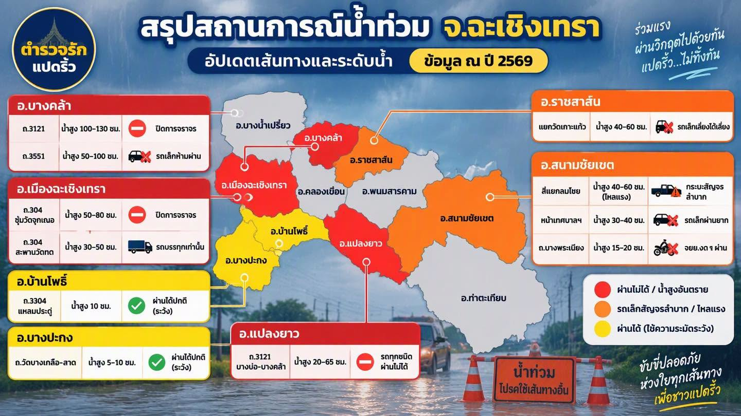
Awaiting source verification · Approximately Sat 3 Oct 2026 11:00
Road conditions may have changed. Check before travelling.
District: Mueang Chachoengsao
Latest available status: Road closed · Awaiting current confirmation
Road closed
Reported water depth 50–80 cm
Approximately Sat 3 Oct 2026 11:00 · As stated by the sender
This record does not yet include the latest closure or reopening notice.
Subdistrict, coordinates, kilometre markers and traffic direction are unconfirmed. Do not use this to choose a detour or determine whether vehicles can pass.
Reference images and timesDistrict: Mueang Chachoengsao
Latest available status: Trucks only · Awaiting current confirmation
Trucks only
Reported water depth 30–50 cm
Approximately Sat 3 Oct 2026 11:00 · As stated by the sender
This record does not yet include the latest closure or reopening notice.
Subdistrict, coordinates, kilometre markers and traffic direction are unconfirmed. Do not use this to choose a detour or determine whether vehicles can pass.
Reference images and timesDistrict: Bang Khla
Latest available status: Road closed · Awaiting current confirmation
Road closed
Reported water depth 100–130 cm
Approximately Sat 3 Oct 2026 11:00 · As stated by the sender
This record does not yet include the latest closure or reopening notice.
Subdistrict, coordinates, kilometre markers and traffic direction are unconfirmed. Do not use this to choose a detour or determine whether vehicles can pass.
Reference images and timesDistrict: Bang Khla
Latest available status: No small vehicles · Awaiting current confirmation
No small vehicles
Reported water depth 50–100 cm
Approximately Sat 3 Oct 2026 11:00 · As stated by the sender
This record does not yet include the latest closure or reopening notice.
Subdistrict, coordinates, kilometre markers and traffic direction are unconfirmed. Do not use this to choose a detour or determine whether vehicles can pass.
Reference images and timesDistrict: Plaeng Yao
Latest available status: Closed to all vehicles · Awaiting current confirmation
Closed to all vehicles
Reported water depth 20–65 cm
Approximately Sat 3 Oct 2026 11:00 · As stated by the sender
This record does not yet include the latest closure or reopening notice.
Subdistrict, coordinates, kilometre markers and traffic direction are unconfirmed. Do not use this to choose a detour or determine whether vehicles can pass.
Reference images and timesDistrict: Ratchasan
Latest available status: Small vehicles should avoid this route · Awaiting current confirmation
Small vehicles should avoid this route
Reported water depth 40–60 cm
Approximately Sat 3 Oct 2026 11:00 · As stated by the sender
This record does not yet include the latest closure or reopening notice.
Subdistrict, coordinates, kilometre markers and traffic direction are unconfirmed. Do not use this to choose a detour or determine whether vehicles can pass.
Reference images and timesDistrict: Sanam Chai Khet
Latest available status: Difficult for pickup trucks (strong current) · Awaiting current confirmation
Difficult for pickup trucks (strong current)
Reported water depth 40–60 cm
Approximately Sat 3 Oct 2026 11:00 · As stated by the sender
This record does not yet include the latest closure or reopening notice.
Subdistrict, coordinates, kilometre markers and traffic direction are unconfirmed. Do not use this to choose a detour or determine whether vehicles can pass.
Reference images and timesDistrict: Sanam Chai Khet
Latest available status: Difficult for small vehicles · Awaiting current confirmation
Difficult for small vehicles
Reported water depth 30–40 cm
Approximately Sat 3 Oct 2026 11:00 · As stated by the sender
This record does not yet include the latest closure or reopening notice.
Subdistrict, coordinates, kilometre markers and traffic direction are unconfirmed. Do not use this to choose a detour or determine whether vehicles can pass.
Reference images and timesDistrict: Sanam Chai Khet
Latest available status: Motorcycles should not pass · Awaiting current confirmation
Motorcycles should not pass
Reported water depth 15–20 cm
Approximately Sat 3 Oct 2026 11:00 · As stated by the sender
This record does not yet include the latest closure or reopening notice.
Subdistrict, coordinates, kilometre markers and traffic direction are unconfirmed. Do not use this to choose a detour or determine whether vehicles can pass.
Reference images and timesDistrict: Ban Pho
Latest available status: Passable with caution · Awaiting current confirmation
Passable with caution
Reported water depth 10 cm
Approximately Sat 3 Oct 2026 11:00 · As stated by the sender
This record does not yet include the latest closure or reopening notice.
Subdistrict, coordinates, kilometre markers and traffic direction are unconfirmed. Do not use this to choose a detour or determine whether vehicles can pass.
Reference images and timesDistrict: Bang Pakong
Latest available status: Passable with caution · Awaiting current confirmation
Passable with caution
Reported water depth 5–10 cm
Approximately Sat 3 Oct 2026 11:00 · As stated by the sender
This record does not yet include the latest closure or reopening notice.
Subdistrict, coordinates, kilometre markers and traffic direction are unconfirmed. Do not use this to choose a detour or determine whether vehicles can pass.
Reference images and timesApproximately 11:00 on 3 Oct 2026, based on information supplied by the user. The original image shows only the year 2026 and does not state a date or time.
Image colours are the creator's grouping. They do not represent current district-wide risk.